Mount Saint Helens is located in southwest Washington, just under a 3 hour drive from Seattle. On the morning of May 18th, 1980 the volcano erupted, changing the face of the mountain forever. Following a 5.1 richter scale earthquake (caused by a huge surge of magma) the peak of the mountain collapsed and an avalanche, followed by a huge explosion spewed rock, ice and mud across a vast area of the surrounding Toutle River valley.

The explosion occurred in conjunction with a huge plume of steam and grey ash that went high into the air, covering everything in its path across eastern Washington state and even beyond (11 states). Day turned to night in that cloud of ash. This chaotic eruption lasted for 9 hours!
The surrounding forest was destroyed, the powerful force knocking trees over like twigs. Approximately 150 square miles (nearly 250 square kilometres) of forest was destroyed! The rock and mud was like wet cement covering everything in its path, leaving behind a grey landscape so alien from the green forest that lay there before.

The mountain summit was reduced by 1300 feet (400 metres), leaving behind a massive horseshoe shaped, mile wide crater where the peak had once been. The nearby Spirit Lake was lifted 200 feet / 60 metres by the shifting earth and filled with dead trees. An impressive display of mother nature in her most devastating form!
Sadly 57 people and countless wildlife lost their lives during the eruption. Some of the people killed were up to 13 miles / 21 kilometres away! This is the deadliest and most destructive volcanic incident to occur in the United States (news reports at the time estimated that the cost to repair bridges and roads alone was $150 million)!
This video gives a good summary of the events that unfolded during the eruption.
In 1982 the area was declared a national monument and has since been left to recover more or less unaided by human intervention. Almost immediately animals that had been underground and survived, started to dig their way to the surface, bringing plant seeds and pollens with them. Other animals and birds started to come back to the area. This is where the resilience of nature shines through; from the destruction new life grows.
I vaguely remember seeing the eruption on the TV news as a kid back in Australia in 1980. Out of curiosity this was one of the many places I had on my “must visit someday” list. Flash forward 31 years and I finally made it!

October 13th, 2011
Mount St. Helens National Volcanic Monument
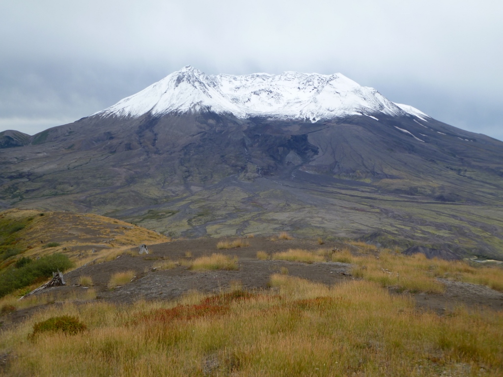
As I drove out of the early morning darkness, into the monument area, the first sight of the snow covered mountain made me smile. Seeing that crater, even from a long distance was very impressive.
I made numerous stops along the way towards Mount St. Helens snapping photos in the crisp morning air. One nice stop was Coldwater Lake, a lake that didn’t even exist until the volcanic eruption occurred, the debris literally dammed the Coldwater Creek and the lake was formed (nearby Castle Lake was created in the same way).

There were impressive views of the mountain and the Toutle River Valley at the Elk Rock, Castle Lake and Loowit viewpoints, but the highlight view is from the Johnston Ridge Observatory which is also the end of the road into the monument area. The observatory is built straight in front of the mountain and is named in honour of David A. Johnston a volcanologist who died during the eruption. Nearby there is a memorial to all that died on that day, with the mountain as its backdrop.

David A. Johnston was a key scientist on the volcano monitoring team of the United States Geological Survey (USGS). He was working at an observation post about 6 miles (10 km) from the volcano and is famous for being the first to report the eruption, broadcasting the message “Vancouver! Vancouver! This is it!” before he was gone forever (his remains have never been found, but remnants of his trailer were located in 1993). Note: Vancouver, Washington is where the main USGS volcanic observatory is located.

The Johnston Ridge Observatory has a museum and theatre displaying information on the events leading up to the volcanic eruption and the aftermath. They show a very good movie on what happened, and also of the recovery of the wildlife and plant life in the valley afterwards. Very interesting, and when the movie ends, a large curtain lifts to reveal a huge window and a spectacular view of Mount St. Helens!

From the observatory it is possible to take numerous long or short hikes into the surrounding countryside and the valley below. It is also possible to climb the mountain itself, but I was not prepared or equipped for such a venture on my visit, so I decided to do the Boundary Trail and then go up the Harry’s Ridge Trail (a round trip hike of 8.5 miles/13.7 Kilometres) which promised great views of the surrounding countryside.
Early into the hike I had a rather comical yet treacherous moment on a steep section of the Boundary Trail. A camera case fell out of my pocket and off the trail, sitting there on the steep slope. It was too dangerous to climb down and get it as the steep slope was all loose dirt and rocks. It was highly likely I would have slipped and fallen to my death far below, so what did I do?
I didn’t want to walk away and leave it, so I lay down on my stomach in the wet dirt of the trail, ensuring most of my weight was on the trail rather than hanging over the edge, and stretched over the side of the trail, reaching down the slope with my long spider monkey like arms (lucky), it was a bit hair-raising looking head first down that steep drop but I managed to get a finger on the case and retrieve it! A bit muddy afterwards but all good!

All along the trail great views were provided and it was interesting seeing the erosion caused by rivers and water runoff, but also the recovery of the area by plant life. Smashed trees lay visible on the surrounding hills, I noticed Elk hoof prints everywhere and occasionally heard a buck bugling in the valley below, but never saw them. After a couple hours I was sitting at the top of Harry’s Ridge, admiring the spectacular 360 degree view of the Toutle River Valley, Mount St. Helens, Spirit Lake (over 30 years later the lake is still strewn with thousands of dead trees floating on its surface) and Mount Rainier (to the north).

It was a cold day (at times the wind had quite a bite to it).The sky was fairly grey, but there was no rain so the views were clear, which was fantastic!
")
After taking some time to enjoy the scenery, I made my way back along the trail to return to the observatory, taking yet more photos and enjoying the never-ending views. I am so glad I finally made it to Mount St. Helens National Volcanic Monument; it was an amazing day, that displayed Mother Nature at her most devastating beauty. Something that I will never forget!

One Comment Add yours